
It is 300 years in the future, and our present San Jose is now history. What objects, sounds, or other artifacts would you preserve to give our ascendants (human or nonhuman!) a sense of our 2019 lives?
What follows is a collective attempt at constructing an electronic time capsule; that is, a cache of artifacts that might assist future beings in understanding our present moment. Rather than “bury” the time capsule, we are presenting these artifacts online so that living beings can access them, now and into the future.
Anonymous: Race Street Fish and Poultry

Photographer’s name: Anonymous
Date Taken: August 15, 2019
General Location: Race Street and W San Carlos, San Jose CA 95126

Photographer’s name: Anonymous
Date Taken: August 15, 2019
General Location: Race Street and W San Carlos, San Jose CA 95126

Photographer’s name: Anonymous
Date Taken: August 15, 2019
General Location: Race Street and W San Carlos, San Jose CA 95126
Race Street Fish and Poultry used to be my dad’s go to spot to buy fresh seafood to cook at home. Most of the time when I would accompany him, it was just to purchase the produce and then go home to cook it. But every once in a while, he would let me order something from the kitchen. I would get the Fish and Chips. They were the biggest portions and i would dunk my fish in the side tartar sauce. The clam chowder was delicious too. I remember ordering my food and getting to pick it up and eat it outside during the summer. The closure came in stages. They first shut down the selling of produce but kept the kitchen operational. The last time I went i order Fish and Chips and was lucky enough to have my sibling get me a t-shirt from there before they closed it for good.
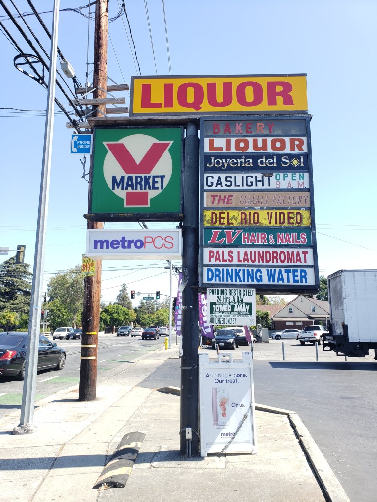
Anita Castillo: Y Market

Photographer’s name: Anita
Date Taken: August 8, 2019
General Location: White Road between East Hills and Florence
Photographer’s name: Anita
Date Taken: August 8, 2019
General Location: White Road between East Hills and Florence
The Y Market will always hold a special place in my heart. I grew up on Doris Ave off of East Hills and White Rd. I went to Cureton, then Joseph George, then James Lick so I used to stop at the Y Market almost every day once I was allowed to walk home from school. From grabbing a soda or chips or to get my granny some smokes, the Y Market seemed like the epicenter for my little world. I would meet friends there, or see my brother with his friends (and get ignored because he was too cool for a younger sibling).
More specifically, I remember going to the Y Market for my grandma to get her “smokes” as she would call them. I also remember the woman who worked there at the time was named Nancy, and she would sell me smokes, for my grandma, at age 13. Granted, they would only sell them to me if they saw my granny waiting in the car outside but still, I felt special.
That Y Market sign still gives me the feels when I visit and if I could physically put the sign in the time capsule, I would.
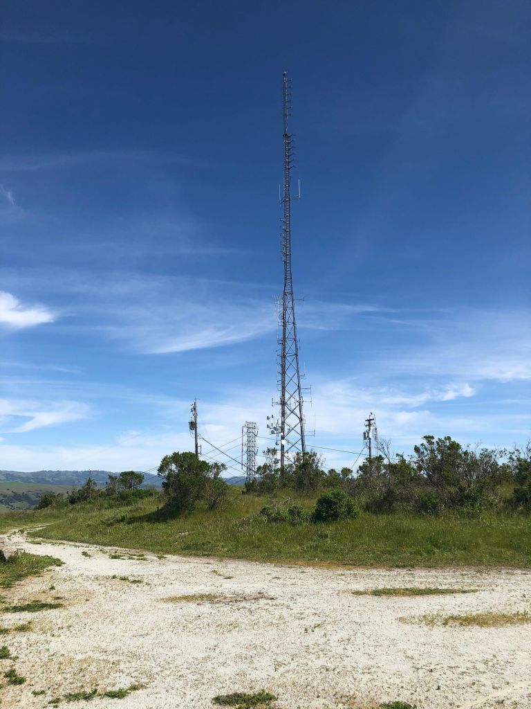
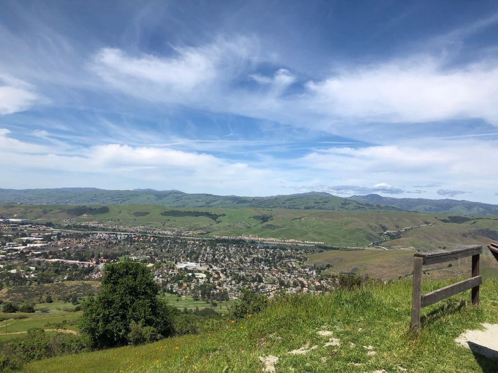
Buckley: The View of the City from the South

Photographer’s name: Buckley
Date Taken: April 13, 2019
General Location: Santa Teresa County Park, Coyote Peak, View of San Jose from Coyote Peak (Muwekma Ohlone, Amah Mutsun Lands)
Photographer’s name: Buckley
Date Taken: April 13, 2019
General Location: Santa Teresa County Park, Coyote Peak, View of San Jose from Coyote Peak (Muwekma Ohlone, Amah Mutsun Lands)
Photographer’s name: Buckley
Date Taken: April 13, 2019
General Location: Santa Teresa County Park, Coyote Peak, View of San Jose from Coyote Peak (Muwekma Ohlone, Amah Mutsun Lands)

Photographer’s name: Buckley
Date Taken: April 13, 2019
General Location: Santa Teresa County Park, Coyote Peak, View of San Jose from Coyote Peak (Muwekma Ohlone, Amah Mutsun Lands)
I am adding these four photos of Santa Teresa County Park, including the view of San Jose from Coyote Peak, to the time capsule. As a young person growing up in south San Jose, I hiked this park’s trails with my parents often. I grew up sheltered & christian & closed-off to a lot. It feels significant to walk these trails again in April 2019, with my partner, as a queer, genderqueer person who has accessed top surgery & worked on self-acceptance: a process of learning & unlearning. For me being in the quiet big-ness of nature was back then, and continues to be now, a grounding and supportive source of energy. In April 2019, I also take this park in with a more critical perspective than I did as a young white person. I notice the IBM facility in stark contrast to the natural hillside, I notice the power lines crossing this park on land that a white settler government claims ownership of. I now understand in a different way that I am on the indigenous lands of the Muwekma Ohlone people, the Amah Mutsun people. A well-known news source calls this place a “hidden jewel”. What will the next 300 years bring?
Buckley is a white, queer, genderqueer person, with a chronic disease who grew up in south San Jose.
carlos: Surfer’s Cry

Photographer’s name: Carlos
Date Taken: August 30, 2019
General Location: San Jose
The Torquays were a surf band from San Jose, composed of three brothers Raul, David and Pete Martinez on guitars and bass, and Jim Sierra on drums. They released their only record in 1964, with the rolas “Escondido” on one side and “Surfer’s Cry” on the flip.
“..a slow moody number,…Very cool, with a double picked reverbed blues break a la B. B. King.” – Phil Dirt, on the song, “Surfer’s Cry”.
Going to pulgas, garage sales, segundas is a hobby of mine, passed on to me by my moms and pops. I bought this record at the De Anza flea market for a few bucks, having never heard of the songs on it. The title “Surfer’s Cry” was what appealed to me.
I love surf instrumental music, but don’t know many other brown folks who do. Maybe I don’t go out much to find y’all. What a treasure to hold in my hands a record from the past, of a trio of hermanos from my hometown sanjo, who loved and played surf!
Recently during my familia’s annual Christmas Eve party, the Ventures, “Walk, Don’t Run” randomly came on the party’s loudspeakers, a surf classic and a personal favorite. My tio said “Your dad loved this song”. My heart cried with joy.
carlos was born to immigrant parents and raised in west side san jose.
Elizabeth Barcelos: Furtado’s

Photographer’s name: Unknown
Date Taken: Unknown
General Location: East Santa Clara between 28th and 101
I
spent my childhood in Little Portugal only to watch it fade in my adulthood.
There used to be four Portuguese bakeries on our stretch of Santa Clara and
Alum Rock. Now we’re down to one. I went to Portuguese school with four full
classes of kids. Where I teach now, we’re struggling to keep kids year in and
year out. Sousa’s Restaurant is gone and while I never liked it much and Adega
is a wonderful replacement, I hear more about San Jose’s only Michelin starred
restaurant from clout chasers than the people who built this community. It’s
for gente fina.
But the biggest blow was losing Furtado’s. My
rhinestone crown for being a sidemaid in the Holy Ghost Festivals came from
here. Children’s books in Portuguese, saint statues and devotional cards, gold
charms for the pendant I wore to church on Sundays. Smaller stores have picked
up some of the slack, but now I’m pretty sure that these three buildings facing
Five Wounds are still standing empty. Our church is over a hundred years old
and pretty enough for a postcard — or a Southwest ad — but it’s surrounded by
this void that’s ripe for gentrification.
Gaby Serrano: Pan dulce from El Chapparral & Travel Route
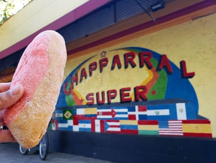
Photographer’s name: Gaby
Date Taken: Aug 12, 2019
General Location: 1001 East Santa Clara Street, San Jose CA 95116
Photographer’s name: Gaby
Date Taken: Aug 13, 2019
General Location: n/a
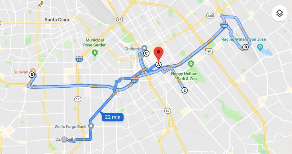
When my siblings and me were little our mom would drive us to El Chaparral on the weekends. That supermercado used to have a bakery inside that made my favorite pan dulce. It’s an oval-shaped pastry with sand colored bread and a bright pink topping covered with a big dusting of granulated sugar. I wish I could submit the smell of fresh baked pan dulce, the overwhelming view of three entire walls worth of glass cases filled with a variety of pan dulces, or better yet… a pan dulce sample. Pan dulce runs remind me of the drive to SJ from Campbell (17N to 280S exit on 10th/11th) and the visual confirmation we made it once I spotted the (now non-existent) mural that covered the entirety of El Chaparral’s parking lot wall. That drive, and others like it, in a way reflect what it was like growing up in SJ’s periphery. I’ve probably spent more time driving across SJ’s surfaces than actually in it. I’m including a driving route from my house to places I frequent…maybe 300 years from now someone will want to visit my old stomping grounds.
LauraAmy Patterson: We Will Prevail(?)

Photographer’s name: LauraAmy
Date Taken: unknown
General Location: unkonwn

Photographer’s name: LauraAmy
Date Taken: unknown
General Location: unkonwn
With trembling, excited energy I start the task of choosing. I see the posts, I think to myself ‘God thank you that there are others who see what is really happening all around us’. I drive down Lawrence expressway on the way to one of my bread and butter jobs. I pass the corn palace, I see the fenced off farm house and the notice of development “proposal”; when it hits me.
Something had been working In me all along, bubbling just below the surface.
My house.
It took seeing what will surely be the sight of one of the absolute last suburban fields, for me to fully grasp what will be lost when they uproot my trees that the possums have lived happily and quite peacefully. When the countless other species of flora and fauna will be uprooted as a bulldozer comes and knocks it all to the ground. Deemed too “pricey” to fix up. Best just start a new. Fix it up then sell it for more! Yes, yes, or knock it down build something pest free, clean and fresh and new for more money than anyone who was born and raised in San Jose could ever afford. With a pristine yard and “ornamental” fruit.
Yes my house, home to alligator lizards, robins and finches, (the blue birds and owls are gone, have been for years) hummingbird, dragon and butterfly. We used to have snakes and a family of racoons. Newts too. I think they vanished some time this last decade with the crickets (oh what sweet lullabies they made!)
My house with its giant trees where silkworms used to live and grow. My house where once when I was newly sober and so broken inside- a sparrow came and landed on my knee.
My house where from my childhood room I could see the tungsten glow of the street lights.
My house where ferns and salvia grow together in harmony. Where miner’s lettuce grows just under a mile from santana row.
My house where no matter what ever happened in it, to step out into front or back garden, I could imagine those beautiful green hills.
I can feel the love of the land, the give and take. Small moments of thanking for what we have been so freely given.
My house. Where I simultaneously feel the sickness of this city and in the same breathe, hope.
Hope.
We Will Prevail.
Anonymous: “UMUNHUM”

Photographer’s name: n/a
Date Taken: unknown
General Locatino: Mount Umunhum

Photographer’s name: n/a
Date Taken: unknown
General Locatino: Mount Umunhum

“UMUNHUM” https://vimeo.com/243187810
[transcribed text:]
Amah Mutsun Tribal Band and Mount Umunhum
“when you come to an area that you know the ancestors were there, I mean you just know by looking at it. I could see a land and say yeah our ancestors were there.
i think its like they are telling you are going to be coming back more and more. every time you come back for a ceremony they are there waiting for us.
being there that’s the feeling the ancestors saying you belong here.
welcome. “
“the mountain is waking up and our access to it is coming about and we are able to restore that relationship with Mount Umunhum.
this mountain though is a sacred mountain and the most important thing here is the spirituality of this mountain and its a place to come and pray, a place to heal, a place to ask for help. that’s where we are today.”
“i mean i am very close to certain things and i am close to this. i am very proud of our tribe and i am very proud of the way we look at things we look at nature in the way that you have to honor it. whatever it is, whether it’s a plant, an animal, whatever it is and we want to preserve it.”
“there’s not one inch of land in the united states that is not native american territory. and so you know we ask that people recognize that wherever they are to get to know the tribe on whose land they are and to say a prayer for them and to give acknowledgment to them.”
“this is where our ancestors are and i welcome you. and i hope you enjoy it and help take care of it . welcome . welcome . ”
Li Patron: Camcorder Footage of a LilyLiver Gig
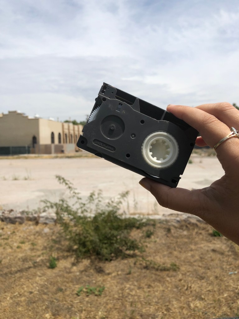
Photographer’s name: Li Patron
Date Taken: August 5, 2019
General Location: The former site of St. Patrick’s Church (9th and Santa Clara)
As a tween I played drums in a riot grrrl cover band called LilyLiver. My bandmates and I all went to the same catholic middle school: St. Patrick’s on 9th and Santa Clara, or as we sired it “St. Raunchie’s.” Like so many freaky adolescents before and after us, punk rock electrified our deadbeat lives. I would include in the time capsule the grainy camcorder footage of us performing at the church festival, wearing our mid-1990s early internet approximations of what bad teens would wear to a gig. I want future generations to know that, once upon a time, five disheveled children lashed out. We spent weeks perfecting our screams in my East Side San Jose garage so that we might hop around in a schoolyard screeching white boy, don’t laugh, don’t cry, just dieeeeee at top volume, startling the churchgoers.
Li Patron lives and writes in her hometown of San Jose, CA. Find more of her writing at www.romancingthevoid.com.
Maureen (aka Dead Mall): Neon Signs of Midtown

Photographer’s name: Maureen aka Dead Mall
Date Taken: unknown
General Location: San Carlos and Bascom
So many nights driving through Midtown on San Carlos, seeing all the vintage neon signs. It’s where I could go to clear my thoughts and unwind.
October: The Summertime Smell of Lake Cunningham
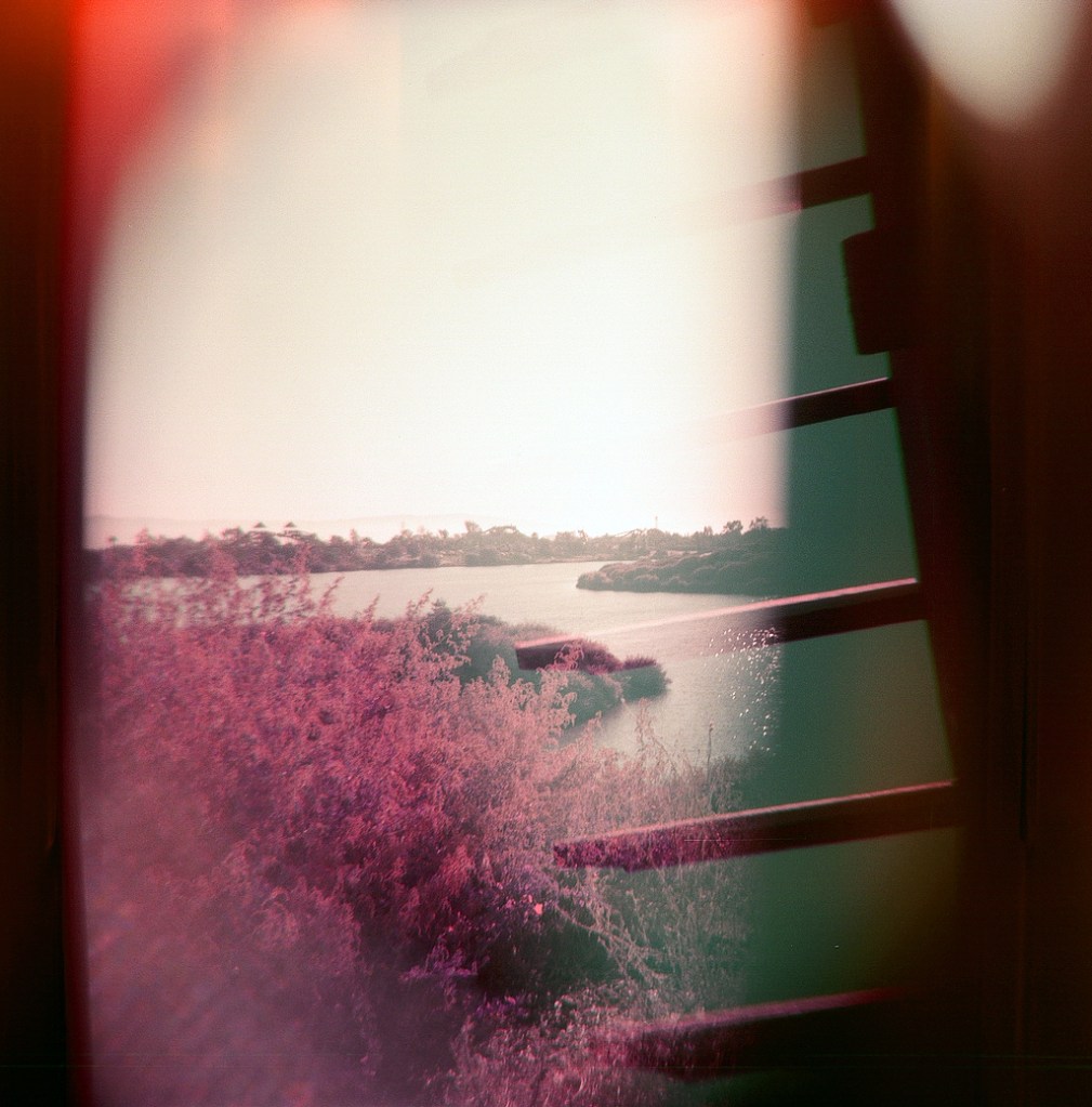
Photographer’s name: October
Date Taken: June 2019
General Location: Lake Cunningham Regional Park

Photographer’s name: October
Date Taken: June 2019
General Location: Lake Cunningham Regional Park
This is something that isn’t possible to submit but Lake Cunningham has a particular smell in the summertime. It’s a combo of like, whatever hot-leafy nature smells are there, bbq, that nasty lake, and pollution. Every time I encounter that smell it immediately takes me back to being 15 hosing duck shit off the docks. Is it cliché to say burnt almond cake? If not, burnt almond cake. What else…maybe a recording of ambient sounds from my grandmother’s house. The streets of the eastside can be a constant competition of exhaust sounds vs blaring oldies. It’s a combo that sounds like home.
LIVING HISTORIES is an occasional series of collaborative articles that bring together the perspectives of multiple contributors. Through this series, Archive408 aims to create a simple, low-stakes way for people to participate in archiving our landscape.
